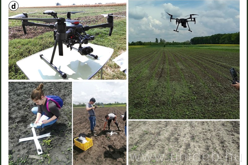
The researchers of the Faculty of Science and Technology of the University of Debrecen are developing a methodology for predicting the moisture content of the soil by involving artificial intelligence. The new type of procedure carried out with multispectral and thermal cameras mounted on unmanned aerial vehicles, can make yield optimization more efficient and, according to plans, will also be available to farmers.
The research was based on a GINOP project related to precision agriculture, within the framework of which in 2019 the Department of Natural Geography and Geoinformatics of the Faculty of Science and Technology worked together with industrial players on how to effectively determine soil moisture content in field environments.
– Since we also deal with aerial mapping, we participated in research and development by setting up a hypothesis that the moisture content can also be determined using drone aerial photographs. Traditionally, in the field, this is done by inserting a sampler into the soil, but this would be quite difficult on a hundred hectares. It also works with aerial images of large areas, but their spatial resolution is small, a frame of 10 or 20 meters, while it should be examined with a resolution of roughly 10 cm if the field plot is so heterogeneous. In addition, the satellites orbiting the Earth are only able to take repeated images of the examined area after several days. This is how the question came about, what could be done more effectively – László Bertalan, assistant professor of the Department of Natural Geography and Geoinformatics of the Faculty of Science and Technology, recalled the beginnings.
As part of the project, tests were carried out on a corn field and its fallow area on the border of Hajdúböszörmény, by installing a thermal camera on the department’s industrial category drones and creating so-called thermal orthophoto mosaics, a kind of heat map. Different data processing combinations were used to determine how the soil moisture content could be determined, for which it was necessary to know the actual distribution of soil moisture at the time of the study.
The specialists involved in the research collected soil samples, in which the moisture content of the soil at the given points was determined under laboratory conditions. At the same time, drone data collection was also carried out, on the one hand with a thermal camera, and on the other hand with so-called multispectral mapping, when the differences in the soil surface were shown based on solar radiation reflected in different ranges of the electromagnetic spectrum. After all this, they calculated the possible soil moisture content based on the drone thermal camera and compared it with the values of the soil samples measured in the laboratory.
The research group published its results in the journal Computers and Electronics in Agriculture, and the article was recently recognized with a Publication Award by the István Gróf Tisza Foundation for the University of Debrecen.
Our study is about the methods by which we can most effectively estimate the moisture content. If, for example, the soil surface is 35 degrees on the drone heat map, but the moisture content of the given soil sample is 20 percent, then with the help of artificial intelligence, including machine learning, we can determine a statistical relationship if there are enough soil samples. The basis is the correlation between the moisture content of soil samples and moisture values derived from combinations of drone data.
The publication presents the optimal settings with which the most accurate results can be achieved and with which farmers will be able to use the method in practice. All they have to do is fly into the area with drone mapping as a first step, take digital aerial photographs and process the data using the appropriate computer software. The system of equations can then be created using the tools of machine learning, the result of which is a soil moisture map.
Although the GINOP project has ended, the research continues at the Department of Natural Geography and Geoinformatics, one of our PhD students, in cooperation with KITE Zrt, is conducting further investigations on an experimental plot near Tépe. The methodology is therefore still being finalized, we are now trying to clarify the limitations of the technology in order to be able to provide domestic farmers with a uniform methodology at the end
– the specialist concluded.
They are studying, among other things, whether the method is reliable in all seasons, whether it is affected by the weather, different temperature and precipitation conditions or the physical characteristics of the soil.
We want to compile a large data set so that the artificial intelligence model, which prepares the final equation for this, is as reliable as possible. By definition, this must always be developed specifically for a given place. We can develop the basic framework and then it can be applied to each plot based on the local survey series. If our method is finalized, it can contribute to making the optimization and maximization of yields more effective when integrated into precision irrigation planning
– said László Bertalan.
(unideb.hu)


